NON-IMPERIAL TOPONYMIC ELEMENT DISTRIBUTION IN THE ECUADORIAN HIGHLANDS
(DISTRIBUCIÓN DE ELEMENTOS DE TOPÓNIMOS NO-IMPERIALES EN LA SIERRA ECUATORIANA)
© 1999 Jim Belote & Linda Belote
University of Minnesota Duluth
(This is a work in progress and should not be cited or quoted without permission. Comments, suggestions and criticisms are welcome. Contact jbelote@d.umn.edu or lbelote@d.umn.edu ).
Before the conquest by the imperial armies of the Incas and then, a few decades afterwards, in the early 1500s, by the imperial armies of the Spanish, the Ecuadorian highlands had been home to a variety of peoples, speaking a variety of languages. Both imperial languages (Quichua--as it is commonly known in Ecuador--and Spanish) soon displaced most of the local non-imperial languages. Few details are available in the records written at the time of the Spanish conquest (and thereafter) concerning the languages that were being displaced. Furthermore, under both the Inca and Spanish occupations of the Ecuadorian highlands there was considerable mixing and moving of populations. Under the Incas there was a policy of permanently transferring populations from one part of their vast empire to another--to provide needed skills, to reduce unified opposition, to reward with new land people who had served the state, etc.--these moved populations were known as "mitmaccuna." The Incas, and the Spaniards after them, also temporarily moved people from one region to another in order to accomplish work desired by the state, such as, for example, mining. This labor tax was known as the "mita" under the Incas, and the Spaniards kept up the practice under the same name (but under much worse conditions) in their administration. Thus the Spaniards transferred native populations from as far away as northern Ecuador to the gold-mines at Zaruma, in southern Ecuador. The most severe features of this forced labor under Spanish administration were leveled at native populations which retained some control over their own lands. In order to avoid the mita and other forms of tribute exacted upon them, many people gave up their traditional lands, and moved elsewhere. In other words, the Ecuadorian highlands experienced a considerable degree of population mixing several hundred years ago.
Several years ago we began to investigate the possibility that toponyms (place names) might provide some clues as to the ethnic past of the Saraguro region in south highland Ecuador. (In 1994 we distributed a paper on this topic, entitled "Toponyms and Saraguro Origins [Topónimos y los Orígines de los Saraguros]" to various individuals and institutions in the Saraguro area. We later expanded the area of concern and presented a paper entitled "Cañaris, Paltas and Saraguros: Toponyms and Ethnic Boundaries in Southern Ecuador" at the 24th Annual Midwest Conference on Andean and Amazonian Archaeology and Ethnohistory at Beloit College in 1996.) Where did the ancestors of the modern-day Saraguros come from? Who lived in the Saraguro region before the Inca conquests? Before the Spanish conquest? After the Spanish conquest? There are, of course, other means of trying to understand the ethnic past of the region. What do the Saraguros themselves say? How do others account for their origins? What about documentary evidence? Patronyms/Matronyms? The archaeological evidence? Our task at that point was not (and still isn't) to untangle all these strands of evidence. It is true that we will have occasion to refer to these limited sources of evidence as we proceed. But our goal here, to restate it, is quite limited. What do toponyms tell us (or what do we think they are telling us)?
And this limited goal is even further limited. Rather than study each known local (and, perhaps, unique) toponym (which would be one potentially productive course of action) we decided to approach the search for clues by examining the distribution of toponymic elements (in most cases probably morphemes), most of which appeared to be non-imperial, i.e. coming neither from the Spanish of the Spanish Empire nor from the Quichua of the Inca Empire. Are there patterns of density of toponymic element distribution which would seem to indicate a localization of distinct ethnic populations in different parts of the southern Ecuador?
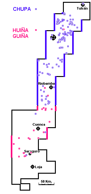
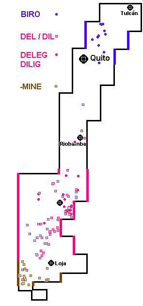
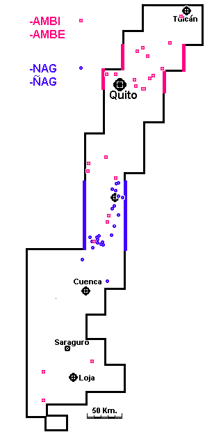
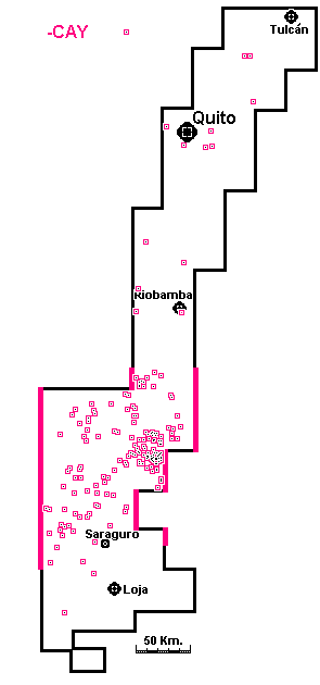
Our first attempt was to determine if we could define "Palta" (to the south) and "Cañari" (to the north) regions through toponymic elements, and to determine the place of the Saraguro region vis-a-vis those two groups. We concluded (primarily because of the density distribution of the elements CAY , DEL (not the Spanish "del") and HUIÑA, that the Saraguro region probably lay within the southern boundaries of some kind of Cañari territory at some point. On the other hand, presumed connections with the "Paltas" could not be found (note the frequency distribution of NUMA and MINE south of the Saraguro region)--there was no interesting overlapping of toponymic elements between the Saraguro region and regions to the south.
Therefore, whether or not a "Cañari" speaking people were part of the ancestry of modern Saraguros, the Saraguros almost certainly live in a territory once strongly influenced by the Cañari language in the form of toponyms. But there were a couple of other issues. Could ancestral Saraguro populations have included significant numbers of non-imperial language speakers from more distant parts of highland Ecuador? And were the Saraguros in part, or almost wholly, descendents of mitmaccuna from Peru or Bolivia as some traditional accounts indicate? Even more particularly, could they have descended from Inca royalty or royal troops, rewarded for their service by land grants in the Saraguro region?
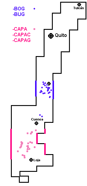
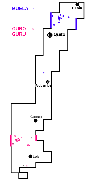
Two elements, -CAPA and SHAPA, although possibly of imperial (Inca) origin, are heavily skewed in their distribution to the region around (and somewhat beyond) the Saraguro region. In the Quichua language they generally have connotations of royalty (CAPA) and uniqueness (SHAPA). What might this tell us? Another possible Quichua element, HUIÑA, (meaning in Quichua, "emergent," or "growing"--but in the Saraguro area connoting a kind of spirit being, both beneficient and dangerous and usually associated with lakes--is heavily distributed in the Saraguro region and the northern Canari region, but not elsewhere. What does this tell us? And, finally, the element GURO (as in saraGURO). GURO is almost entirely restricted in distribution to the greater Saraguro region. At this time we have no satisfactory ideas about its linguistic links or what its distribution means other than that, perhaps, it may help define the boundaries, at some uncertain time in the past, of a group at least in part ancestral to the Saraguros.
We came to realize that a fuller understanding of the meaning of toponymic element distribution would be enhanced by expanding the geographical reach of our investigation. By expanding our geographical reach we would clarify the apparent "uniqueness" of what we found in the Saraguro area. Did the Saraguro region really stand alone in the frequency of distribution of these elements? Thus the present work includes plotting of toponymic elements as far north as the Colombian border and certainly includes the territories of more than just the Palta and Cañari groups which surrounded the Saraguro region.
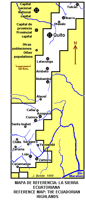
Because Ecuador's Instituto Geográfico Militar (IGM) had produced excellent maps of the region at a scale of 1:50,000, we decided that the most practical way to avoid distributional bias--based on knowledge of localized toponym distribution-- would be to use IGM maps as our sole source of toponyms.
The maps presented below present the distribution density of the toponymic elements we have selected in a strip of the Ecuadorian highlands stretching between the borders of Peru and Colombia. The toponymic elements plotted come from 103 topographic maps published by the IGM. (Significant toponymic elements known to us but not recorded on the IGM maps have not been plotted on our distribution maps.) The borders of the maps shown below correspond to the outer borders of the IGM maps. Moving from top to bottom and left to right (for an idea of coverage note that there are three maps covering the top row), the IGM maps used as sources are La Carolina, Tufiño, Tulcán, Mira, San Gabriel, Huaca, Imantag, Ibarra, Pimapiro, La Bonita, Otavalo, San Pablo del Lago, Mariano Acosta, Mojanda, Cayambe, Nevado Cayambe, Nono, el Quinché, Cangagua, Quito, Sangolquí, Oyacachi, Amaguaña, Pintag. Papallacta, Machachi, Sincholagua, Laguna de Mica, Mulaló, Cotopaxi, Pilaló, Latacunga, Lagunas de Anteojos, Angamarca, Salcedo, San Jose Poaló, Simiatug, Ambato, Sucre, Chimborazo, Quero, Guaranda, Guano, Sicalpa, Riobamba, Pallatanga, Guamote, Tixán, Palmira, Alausí, Totoras, Laguna de Canclón, La Troncal, Suscal, Juncal, Huangra, Santa Rosa de Flandes, Pancho Negro, San Francisco Gualleturo, Cañar, Cola de San Pablo, Naranjal, San Felipe de Molleturo, Chiquintad, Azoques, Guachapala, El Carmen de Pijilí, Chaucha, Cuenca, Gualaceo, Ponce Enríquez, San Fernando, Girón, Sigsig, Uzhcurrumi, Santa Isabel, Yaritzagua, Chilla, Manú, Nabón, Paccha, Selva Alegre, Saraguro, San José de Yacuambi, Zaruma, Santiago, Las Juntas, Yantzasza, Chaguarpamba, Catamayo (La Toma), Loja Norte, Zumbi, Paquisha, Catacocha, Nambacola, Río Sabanilla, Zamora, Guaysimi, Cariamanga, Gonzanamá, Vilcabamba, Río Calvas, and Amaluza.
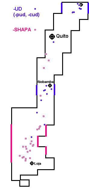
All the toponyms (not just selected toponyms or toponymic elements) on all the maps were entered into computer files along with corresponding coordinates, and later plotted on their own maps (among them, those provided below) to highlight their distribution patterns. We perused the lists in order to seek out what appeared to be elements, and their variants, whose distribution would show significant skewing in the highlands. As indicated above, in all but a few cases we eliminated elements from the imperial languages because they showed no obvious distributional patterns (these included common toponymic elements, well distributed all over the highlands, such as urcu/cerro, yacu/río, cocha/laguna, yana/negro, yurac/blanco, huaycu/quebrada, etc.). We did pick the three probably Inca-imperial elements noted above, CAPA, SHAPA and HUIÑA, because their distribution was skewed towards the Saraguro and the Cañari regions. And, in the present expanded context we have also selected an element with toponymic significance in both imperial languages, CHUPA (having to do with tail, back end, or last in a series, in Quichua, and with such actions as suck, smoke, eat, ingest, or drink in Spanish), because it also has a skewed distribution for no obvious topographic reason (as would be the case for a more restrictively distributed feature such as caves--thus one map has seven occurrences of the Quichua term for cave, "machay," while most maps have none or one. Does this skewed distribution of a doubly imperial element indicate an underlying "cultural" difference between regions? (And should we note that the Quichua element "chaupi" [middle, central] has a skewed distribution covering much the same area as as CHUPA? Probably not, at this time.)
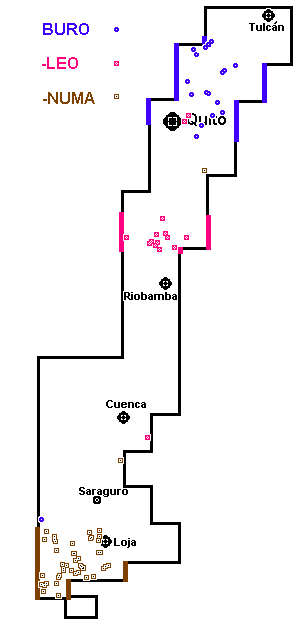
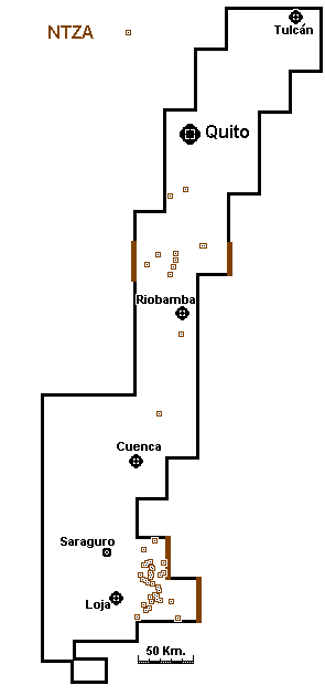
Finally, we note a few other toponyms plotted below. BUELA, BURO, BIRO and AMBI are primarily restricted to the Quito/Otavalo region; LEO to the Ambato region; -NAG and BUG to the Riobamba area. And -UD (-pud and -cud) and -NTZA have a curious bipolar distribution, the first being split between the Riobamba and Tulcán regions, the second between Shuar territory in the upper Amazon region of Zamora-Chinchipe province and a thinner scattering in the Ambato region.
For now, though, we suspend our discussion and present the toponymic element distribution maps. In the next few months we will present a discussion of the findings, the mapping of a few more toponymic elements, and references to published sources of information. And, as indicated above, we welcome comments, criticisms and suggestions. As it is so far, we wish to thank the following for comments, suggestions, criticisms, and map buying forays to the IGM in Quito: Jean Brown, Angel Polivio Chalán Chalán, Angel Polivio Chalán Lozano, Luis Aurelio Chalán, Luis Alfonso Contento, Marcos Contento, Manuel Santos Guamán, Mateo Guamán, Luis Francisco Quizhpe, Segundo Saca Quizhpe, Luis Rodríguez, Frank Solomon, Ronald Lippe, Peter Wogan, Zoila Zhingre, Tom Zuidema and Luisette Zuidema. And we especially thank Leslie Brownrigg for a thorough, detailed and thoughtful written commentary on an earlier version of this work. Any flaws in this work, and the work to come, remain ours.