Pelah Hoyt (with the webpage assistance of Jim Belote)
Web page under construction . First Uploaded March 31, 2004. Last modified April 5.
For more information on birdwatching in Saraguro please contact the Peace Corps volunteer Pelah Hoyt (pelahhoyt@hotmail.com) or the Fundación Wampra which is located across from the Central Park in the town of Saraguro.
The essential printed source on the 1600+ birds of Ecuador (excluding the Galapagos) and therefore on the birds of the Saraguro area for birders and other interested eco-tourists, and the background source for much of the material on these web pages (scientific and common English and Spanish names, likely distributions, endemic or threatened status, etc.), is the two volume set by Robert S. Ridgely and Paul J. Greenfield, published in 2001 at Ithaca by the Cornell University Press: THE BIRDS OF ECUADOR: STATUS, DISTRIBUTION, AND TAXONOMY (Volume I), and THE BIRDS OF ECUADOR: FIELD GUIDE (Volume II). This excellent set is usually available (as of early 2004), among many other places, at the Libri Mundi bookstore in Quito, and at electronic bookstores in the US.
Saraguro is uniquely located where two endemic bird areas intersect the East Central Andean and the Tumbesian. The upper mountains are cloaked in cloud forest (2800 3100m) while the lower area is cut by a spectacular desert canyon (1200m) both habitat types are within an area just 30 kilometers wide! The Tumbesian (EBA) has the greatest diversity of endemic birds of any area in the world. (sources??)
The montane cloud forests around Saraguro are part of the South Central Andes Endemic Bird Area. The South Central Andes EBA has suffered high levels of deforestation. Saraguros forests are recognized as a high priority for conservation by Birdlife International and the authors of The Birds of Ecuador: Status, Distribution, and Taxonomy (Robert Ridgely and Paul Greenfield 2001). In Saraguro, three indigenous communities are conserving some of this cloud forest in the Washapamba Protected Area. Birdlife International considers the Washapamba Protected Area important for the conservation of at least four endemic bird species and identified Washapamba as one of 5 Key Areas for conservation of these threatened birds. Your visit can contribute to the conservation of this important area.
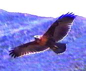
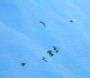
The Tumbesian Endemic Bird Area, a desert region (click here for photos and discussion), contains isolated patches of trees and small ponds. The road into the canyon also provides access to the Rio Pakishapa and Rio Leon (which form the Jubones River at their junction). Highlights include the Tumbes Pewee, Pied-billed Grebe, Least Grebe, Common Gallinule, Black-chested Buzzard Eagle, Lesser Nighthawk, White-tipped Swift, Stripe-throated Hermit, Plain-brown Woodcreeper. More Tumbesian endemics are expected to be found in the area. There have also been unconfirmed sightings of Andean Condors. The area has not been explored but could offer new and unusual finds to an adventurous birdwatcher.
Birdlife International considers the Washapamba Protected Area important for the conservation of at least four endemic bird species and identified Washapamba as one of 5 Key Areas for conservation of these threatened birds. Your visit can contribute to the conservation of this important area. See BirdLife International 2003 BirdLife's online World Bird Database: the site for bird conservation. Version 2.0. Cambridge, UK: BirdLife International. Available: http://www.birdlife.org/ (accessed 1/12/2003)
![]() = Endemics (species whose entire population can only be found only in
a less than 50,000 square kilometer area)
= Endemics (species whose entire population can only be found only in
a less than 50,000 square kilometer area)
Source for information on endemic and threatened status: The Birds
of Ecuador: Volume II, Status, Distribution and Taxonomy
Map references are
provided with general locations of bird watching sites. The regional map
used it is divided into 9 major sections (a-i)--see figure below. Imagine
that each section is further divided into nine smaller sections with the
same sort of alignment (A-I). Thus Washapamba (immediately below) is located
in the "A" (north-west) section of the major section, "h". 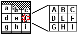
Bird lists below from Pelah Hoyt unless otherwise
noted; [J] after entry = Jim Belote, [L]=Linda Belote, [M]=Mark Olson).
Photos (from Digital 8 video) by Jim Belote
unless otherwise noted.
"The most beautiful forest I've seen on the inner slopes of the Andes in 12 years of birdwatching in Ecuador" - One happy birdwatcher.
Elevation: 2800m - 3100m
Habitat type: Cloud forest
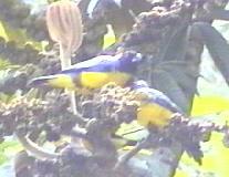
Highlights: ![]() Red-Faced Parrot, Golden-plumed Parakeet,
Red-Faced Parrot, Golden-plumed Parakeet, ![]() Bearded Guan, White-tailed Shrike Tyrant, Gray-Breasted Mountain Toucan, Mountain
Caracara,
Bearded Guan, White-tailed Shrike Tyrant, Gray-Breasted Mountain Toucan, Mountain
Caracara, ![]() Rainbow Starfrontlet, Buff-winged Starfrontlet,
Rainbow Starfrontlet, Buff-winged Starfrontlet, ![]() Flame-Throated
Sunangel,
Flame-Throated
Sunangel, ![]() Amethyst-throated Sunangel,
Amethyst-throated Sunangel, ![]() Purple Throated Sunangel, Purple-backed Thornbill, Tyrian Metaltail, White-bellied
Woodstar, Masked Trogon, Powerful Woodpecker, Strong-billed Woodcreeper, Montane
Woodcreeper, Chestnut-crowned Gnateater,
Purple Throated Sunangel, Purple-backed Thornbill, Tyrian Metaltail, White-bellied
Woodstar, Masked Trogon, Powerful Woodpecker, Strong-billed Woodcreeper, Montane
Woodcreeper, Chestnut-crowned Gnateater, ![]() Jelskiis Chat Tyrant, Undulated Antpitta,
Jelskiis Chat Tyrant, Undulated Antpitta, ![]() Chusquea Tapaculo, Ocellated Tapaculo
Chusquea Tapaculo, Ocellated Tapaculo
How to get there: The Protected Area is located 6 kilometers south of Saraguro on the Panamerican Highway. It is about a 3-hour drive south from Cuenca or an hour and a half drive north from Loja. Parking is available across the highway from the reserve.
Price: $5.00 per person. Tickets can be purchased at the Fundación Wampra, which is located across from the central park in Saraguro. Your visit to Washapamba will contribute to the conservation of this important area.
Notes: One hour or an entire day can be spent birdwatching in Washapamba. A well-maintained trail goes through the forest for about 1 km. The trail enters a small pasture with great birdwatching opportunities and then continues on to a huge Podocarpus tree. The more adventurous birdwatchers can continue up the trail towards the ridge. This part of the trail is steep and a bit rougher, but is much better than most Ecuadorian campo trails. Deeper forest birds such as the Chestnut-Crowned Gnateater can be seen here. The trail passes through a stand of large Clusia trees and an overlook that features an ancient Podocarpus montanus tree.
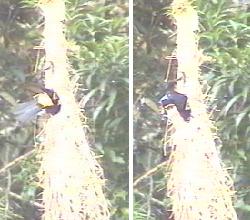
A pair of Northern Mountain Caciques nested in the small pasture clearing between October 2003 and January 2004. The Arrayan tree (Myrcianthes) at the forest entrance fruits between October and December. The Red-faced Parrot, Bearded Guan, and the Grey-Breasted Mountain Toucan are easy to see at this time feeding on the Arrayan fruits. It is possible to see 4 different kinds of hummingbirds at the same time feeding on the large Puchig tree when it blooms in January. Look for the large tree with the yellow blooms in the northern part of the pasture.
Washapamba is owned by three indigenous communities and protects
200 hectares of cloud forest. The Protected Area has the full support of
community members. Unlike the many "paper parks" in Ecuador, the Washapamba
forest is truly being conserved.
Washapamba has been described as a "MUST" stopover on road between
Cuenca and Loja.
Threatened
![]() Red-Faced Parrot, Hapalopsittaca pyrrhops, Loro carirrojo
Red-Faced Parrot, Hapalopsittaca pyrrhops, Loro carirrojo
Golden-plumed Parakeet, Leptosittaca branickii, Perico Cachetidorado
![]() Bearded Guan, Penelope barbata, Pava Barbada
Bearded Guan, Penelope barbata, Pava Barbada
White-tailed Shrike Tyrant, Agriornis andicola
Gray-Breasted Mountain Toucan, Andigena bypoglauca
Non-threatened
Mountain Caracara, Phalcoboenus megalopterus
White-collared Swift, Streptoprocne zonaris
![]() Rainbow Starfrontlet, Coeligena iris, Frentiesrella Arcoiris
Rainbow Starfrontlet, Coeligena iris, Frentiesrella Arcoiris
Buff-winged Starfrontlet, Coeligena lutetiae, Frentiesrella
Aleanteada
![]() Flame-Throated Sunangel, Heliangelus micraster, Solángel
Gorjidorado
Flame-Throated Sunangel, Heliangelus micraster, Solángel
Gorjidorado
![]() Amethyst-throated Sunangel, Heliangelus amethysticollis, Solángel
Gorjimatista
Amethyst-throated Sunangel, Heliangelus amethysticollis, Solángel
Gorjimatista
![]() Purple Throated Sunangel, Heliangelus viola, Solángel Gorjipúrpura
Purple Throated Sunangel, Heliangelus viola, Solángel Gorjipúrpura
Purple-backed Thornbill, Rampomicron microrhynchum
Tyrian Metaltail, Matallura tyrianthina
White-bellied Woodstar, Chaetocercus mulsant
Masked Trogon, Trogon personatus
Powerful Woodpecker, Campephilus pollens
Tourquoise Jay, Cyanolyca turcosa
Strong-billed Woodcreeper, Xibocolaptes promeropirhynchus
Montane Woodcreeper, Lepidocolaptes lacrymiger
Azara's Spinetail, Synallazis azarae
Pearled Treerunner, Margororris squamiger
Streaked Tufted-Cheek, Pseudocolaptes johnsoni
Chestnut-crowned Gnateater, Conopophaga castaneiceps
Undulated Antpitta, Grallaria squamigera
![]() Chusquea Tapaculo, Scytalopus parkeri
Chusquea Tapaculo, Scytalopus parkeri
Ocellated Tapaculos, Acropternis orthonyx
Cinnemon Flycatcher, Pyrrhomyias cinnamomea
![]() Jelski's
Chat-Tyrant, Ochthoeca jelskii
Jelski's
Chat-Tyrant, Ochthoeca jelskii
Rufous-breasted Chat-Tyrant, Ochthoeca rufipectoralis
Dusky-capped Flycatcher, Myiarchus crinitus
Dusky Piha, Lipaugus fuscocinereus
White-banded Tyrannulet, Mecocerculus stictopterus
Smokey Bush-tyrant, Myiotheretes fumigatus
Red-crested Cotinga, Ampilion rubrocristatus
Brown-bellied Swallow, Notiochelidon murina
Mountain Wren, Troglodytes solstitialis
Great Thrush, Turdus fuscater
Hooded Mountain-Tanager, Buthraupis montana
Lacrimose Mountain-Tanager, Ansiognathus igniventris
Masked Flowerpiercer, Diglossopis cyanea
Black-headed Hemispingus, Hemispingus verticalis
Rufous-chested Tanager, Thylypopsis ornata
Gray-Hooded Bush-Tanager, Cnemoscopus rubrirostris
Plushcap, Catamblyrhynchus diadema
Black-crested Warbler, Basileuterus nigrocristatus
Spectacled Whitestart, Myioborus melanocephalus
Rufous Naped Brush-Finch, Atlapetes pallidinucha
Chestnut-capped Brush-finch, Buarremon brunneinucha
Northern Mountain-Cacique, Cacisus leucoramphus
Golden-crowned tanager, Iridosornis rufivertex, Tangara
Coronnidorada [J]
Elevation: 3180m - 3310m
Habitat type: Cloud forest, páramo, and treeline vegetation.
Highlights:![]() Red-Faced Parrot, Golden-plumed Parakeet,
Red-Faced Parrot, Golden-plumed Parakeet, ![]() Bearded Guan, Gray-Breasted Mountain Toucan, Andean Snipe, Noble Snipe,
Band-winged Nightjar,
Bearded Guan, Gray-Breasted Mountain Toucan, Andean Snipe, Noble Snipe,
Band-winged Nightjar, ![]() Rainbow Starfrontlet, Glowing Puffleg, Great Sapphirewing, Golden-Crowned
Tanager, Capped Conebill, Black-Chested Mountain Tanager, Pale-naped Brush
Finch
Rainbow Starfrontlet, Glowing Puffleg, Great Sapphirewing, Golden-Crowned
Tanager, Capped Conebill, Black-Chested Mountain Tanager, Pale-naped Brush
Finch
How to get there: Follow the Panamerican Highway south of Saraguro
for about 3 km. Turn left onto the old Panamerican highway. After about 4 km
a road turns off to the left up to Loma del Oro (also called Las Antenas). This
2-3 km stretch of road is not well-maintained. The birdwatching is good along
the road. From the antennas at Loma del Oro take the trial that goes along the
ridge. After about a half of a kilometer the trail splits. Both trails offer
great birdwatching.
The trail to the right follows the continental divide for miles through
cloud forest, , and páramo/treeline vegetation (click here
for photos of the páramo region) . Mountain Tapir tracks are frequently
encountered along the trail. Spectacled Bears have also been seen in the area.
Note how the bears have chewed-up many achupallas (spiny ground-dwelling bromiliads)
in the páramo around Tambo Blanco and beyond.
The trail to the left leads back to the community of Las Lagunas and the
Huelemon ridge by way of Uritushinga. Uritusinga means "Parrot Beak" in Kichwa
and is also the local name for the tree that produces quinine - an early cure
for malaria. This area is expected to have many more species of
hummingbirds.
Threatened
![]() Red-Faced Parrot, Hapalopsittaca pyrrhops, Loro carirrojo
Red-Faced Parrot, Hapalopsittaca pyrrhops, Loro carirrojo
Golden-plumed Parakeet, Leptosittaca branickii, Perico Cachetidorado
![]() Bearded Guan, Penelope barbata, Pava Barbada
Bearded Guan, Penelope barbata, Pava Barbada
Gray-Breasted Mountain Toucan, Andigena bypoglauca
Non-threatened
Black-Chested Buzzard-Eagle, Geranoaetus melanoleucus
American Kestral, Falco sparverius
Andean Snipe, Gallinago jamesoni
Noble Snipe, Gallinago nobilis
Band-winged Nightjar, Caprimulgus longirostris 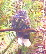
Tourquoise Jay, Cyanolyca turcosa
White-collared Swift, Streptoprocne zonaris
![]() Rainbow Starfrontlet, Coeligena iris, Frentiesrella Arcoiris
Rainbow Starfrontlet, Coeligena iris, Frentiesrella Arcoiris
Tyrian Metaltail, Metallura tyrianthina, Metalura Tiria
Glowing Puffleg, Eriocnemis vestitus, Zamarrito Luciente
Sparkling Violetear, Colibri coruscans, Orejivioleta
Ventriazul
Great Sapphirewing, Pterophanes cyanopterus, Alazafiro
Grande
Rufous-breasted Chat-Tyrant, Ochthoeca rufipectoralis
White-tailed Tyrannulet, Mecocerculus poecilocercus
White-throated Tyrannulet, Mecocerculus leucophrys
Great Thrush, Turdus fuscater
Golden-Crowned Tanager, Iridosornis rufivertex
Black-Chested Mountain-Tanager, Buthraupis eximia
Lacrimose Mountain-Tanager, Ansiognathus lacrymosus
Scarlet-bellied Mountain-Tanager, Ansiognathus igniventris
Masked Flowerpiercer, Diglossopis cyanea
Capped Conebill, Conirostrum albifrons
Spectacled Whitestart, Myioborus melanocephalus
Pale-naped Brush-Finch, Atlapetes pallidinucha
Rufous-naped Brush-Finch, Atlapetes latinuchus
Elevation: 2620m
Habitat type: Native bushes along a creek mixed with pastureland.
Highlights:![]() Rainbow Starfrontlet,
Rainbow Starfrontlet, ![]() Purple Throated Sunangel, Shining Sunbeam, White-bellied Woodstar, Glowing
Puffleg, Giant Hummingbird, Green-tailed Trainbearer, Sparkling
Violetear
Purple Throated Sunangel, Shining Sunbeam, White-bellied Woodstar, Glowing
Puffleg, Giant Hummingbird, Green-tailed Trainbearer, Sparkling
Violetear
How to get there: The trail can be reached by walking south of town along the Panamerican Highway. Turn left off the highway when you pass the shrine to San Vincente. This lovely trail is level and well maintained. It follows an irrigation canal through native shrubs along a small river. Birdwatching opportunities start about one kilometer along the trail and is especially good around the first bridge (about 2 kilometers up the trail).
Notes: This is a great place to see hummingbirds. It is possible to see all eight species of hummingbirds in a single outing. The best time to visit is between November and January when the bushes are in full bloom.
Great-horned Owl, Bubo virginianus
![]() Rainbow Starfrontlet, Coeligena iris, Frentiesrella Arcoiris
Rainbow Starfrontlet, Coeligena iris, Frentiesrella Arcoiris
![]() Purple Throated Sunangel, Heliangelus viola, Solángel
Gorjipúrpura
Purple Throated Sunangel, Heliangelus viola, Solángel
Gorjipúrpura
Shining Sunbeam, Agleactis cupripennis, Rayito Brilliante
Sparkling Violetear, Colibri coruscans, Orejivioleta
Ventriazul
White-bellied Woodstar, Chaetocercus mulsant, Estrellita
Ventriblanca
Green-tailed Trainbearer, Lesbia nuna, Colacintillo
Coliverde 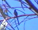
Glowing Puffleg, Eriocnemis vestitus, Zamarrito Luciente
Giant Hummingbird, Patagona gigas, Colibrí
Gigante
Rufous-chested Tanager, Thlypopsis ornata
Southern-Yellow Grosbeak, Pheucticus chrysogaster
Great Thrush, Turdus fuscater
Chiguanco Thrush, Turdus chiguanco
Masked Flowerpiercer, Diglossopis cyanea
Rufous-chested Tanager, Thlypopsis ornata
Rufous-Naped Brush-Finch, Atlapetes latinuchus
Pacific Hornero, Frunarins cinnamomeus, ([lL] [J], Las Lagunas)
Elevation: 1260m - 2000m
Habitat type: Desert canyon region cut by the León, Paquishapa and Naranjo rivers, with isolated patches of irrigated fields and of flood-plain vegetation including trees, and a few small ponds.
Highlights:![]() Tumbes
Pewee, Pied-billed Grebe, Least Grebe, Common Gallinule, Black-chested
Buzzard Eagle, Lesser Nighthawk, White-tipped Swift, Stripe-throated Hermit,
Plain-brown Woodcreeper
Tumbes
Pewee, Pied-billed Grebe, Least Grebe, Common Gallinule, Black-chested
Buzzard Eagle, Lesser Nighthawk, White-tipped Swift, Stripe-throated Hermit,
Plain-brown Woodcreeper
How to get there: Take the road that heads west out of Saraguro towards the small town of Tenta. About a half of a kilometer beyond Tenta you will reach a "Y". Take the road to the left. It leads through the highland indigenous community of Cañicapa then heads down towards the settlement of Papaya and beyond that to a crossing of the Paquishapa river and the settlements of Chayasapa (with ponds) and Chamical (in the heart of the desert canyon area) From Chamical one can proceed on foot, past the outline remains of an ancient structure (possibly pre-Inka) and to La Union--the junction of the Paquishapa and León Rivers .
Notes: The Zona Caliente around Saraguro is part of the Tumbesian Endemic Bird Area. So far only one Tumbesian endemic has been identified but more are expected to be found here. There have been unconfirmed sightings of Andean Condors over the years in this region. The area has not been studied and could offer some new and unusual finds for an adventurous birdwatcher.
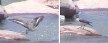 Spotted sandpiper, Actitis macularia [J]
Pied-Billed Grebe, Podilymbus podiceps
Least Grebe, Tachybaptus dominicus
Common Gallinule, Gallinula chloropus
Black-Chested Buzzard-Eagle, Geranoaetus melanoleucus
American Kestral, Falco sparverius
Croaking Ground-Dove, Columbina cruziana
Eared Dove, Zenaida auriculata
Groove-Billed Ani, Crotophaga sulcirostris
Burrowing Owl, Athene cunicularia
Lesser Nighthawk, Chordeiles acutipennis
White-Tipped Swift, Aeronautes montivagus
Stripe-Throated Hermit, Phaethornis striigularis
Plain-Brown Woodcreeper, Dendrocincla fuliginosa
![]() Tumbes Pewee, Contopus punensis
Tumbes Pewee, Contopus punensis
Tropical Kingbird, Tyrannus melancholicus
Vermillion Flycatcher, Pyrocephalus rubinus
Black Pheobe, Sayornis nigricans
Blue-Gray Tanager, Thraupis episcopus
Band-Tailed Sierra-Finch, Phrygilus alaudinus
Hooded Sisken, Carduelis magellanica
Variable Hawk, Buteo polyosoma, Gavilán Variable
([M] [J] [L])
Elevation: 2570m
Habitat type: Native shrubs and riparian vegetation.
How to get there: Follow the Panamerican Highway north from town. At the first bridge look for the White-capped Dipper. Right after the bridge, take the road to your right toward Ñamarin. Take the trail that is immediately to your right as you head up the Ñamarin road. The restaurant at the trailhead serves delicious traditional food and sells local crafts.
Notes: A Black-chested Buzzard Eagle nest was found in the cliffs in 2003. In the evenings owls are frequently heard.
Giant Hummingbird, Patagona gigas
White-Bellied Woodstar, Chaetocercus mulsant
Black-Chested Buzzard Eagle, Geranoaetus melanoleucus
White-Collared Swift, Streptoprocne zonaris
White-Capped Dipper, Cinclus leococephalus
Around Town Map
eH
![]() Purple Throated Sunangel, Heliangelus viola, Solángel
Gorjipúrpura
Purple Throated Sunangel, Heliangelus viola, Solángel
Gorjipúrpura
Black-billed Cuckoo, Coccyzus erythropthalmus
Great-Horned Owl, Bubo virginianus
Streak-Throated Bush-Tyrant, Myiotheretes striaticollis
Thrush, Great, Turdus fuscater, Mirlo Grande
Thrush, Chiguanco, Turdus chiguanco, Mirlo Chiguanco
Green-tailed Trainbearer, Lesbia nuna
Southern Yellow Grosbeak, Pheucticus chrysogaster, Picogrueso
Amarillo Sureño (Saraguro: Chugo)
Hooded Sisken, Carduelis magellanica
Blue-and-White Swallow, Notiochelidon cyanoleuca
Rufous-Collared Sparrow, Zonotrichia capensis (Common in community areas)
Andean Tinamou, Nothoprocta pentlandii (Leon Dormido: Map eH; Loma Huelemon: Map hB)
Chestnut-breasted Coronet, Boissonneaua matthewsii (Above [east] of Ciudadela: Map hE
Crimson-mantled Woodpecker, Piculus rivolii, (Ramos: Map
gC) 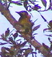
Peruvian Meadowlark, Sturnella bellicosa, Pastorero
Peruano (Saraguro: Chirote) [L][J], Cañicapa: Map
eD) 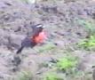
Bar-winged Cinclodes, Cinclodes fuscus, Cinclodesa
Alifranjeado (Laguna Surihuiña: Map
gB) 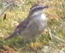
Andean Gull, Larus serranus, ([M] [J], Laguna Chinchilla: Map dH)
White-Capped Dipper: Cinclus leococephalus ([J], Rio San Isidro Map eH)
Andean Condor, Vultur gryphus (reported in the Gera area Map eD
Go to http://www.saraguro.org/ for more information on the Saraguro area.

 Background design from Saraguro woven belts