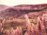
A FEW PRELIMINARY COMMENTS: Below we have begun a listing
of some of the places to visit and things to do in the highly varied countryside
of the Saraguro region. We have not generally given very detailed directions
to places, partly because there is a wide network of trails and roads which
can be used to reach them, partly because we don't remember with precision how
to describe some of the routes (as well as we may know them "on the ground").
Use the maps we have provided as very general aids. Better yet, obtain IGM
maps. And ask questions (if you wish to show off your Quichua, you could
say "¿Maycan ñanta rina [place name with stress on the last
syllable]-man?" [Where is the trail/road to ... ?]--then hope you are pointed
out the way rather than being provided with a flood of directions in Quichua!).
There are few fences around Saraguro, and no PRIVATE PROPERTY, KEEP OUT, or
TRESPASSERS WILL BE SHOT! signs. This is not the (formerly) wild west! You are
free to wander as you will (except right next to people's houses), especially
during the daytime and along existing trails (but remember to keep an eye out
for dogs!). One caution: because there are sometimes cattle rustlers in the
area, don't mess around with untended cattle--you might be mistaken for a rustler
yourself, and the consequences could be disastrous.
Summary Information
Each "place to visit" is accompanied by specific information as indicated in the figure below (the material in parentheses in the figure is given only to show approximate location in cases where that place is not shown on Map 4). Many entries also include expanded descriptions (including links to other sources of information and how to get there (if the name is not given on that map, a further indication of its location will be given).

IGM 1:50,000 Topographic Map Location Reference System
 The best maps of the area are 1:50,000 topographic maps produced by the Instituto
Geográfico Militar (IGM). For serious hiking and trekking it would be
best to have these detailed topographic maps; they are available from the Instituto
Geográfico Militar in Quito; outside Ecuador they are also available
from several web merchants including
OMNI RESOURCES.
The best maps of the area are 1:50,000 topographic maps produced by the Instituto
Geográfico Militar (IGM). For serious hiking and trekking it would be
best to have these detailed topographic maps; they are available from the Instituto
Geográfico Militar in Quito; outside Ecuador they are also available
from several web merchants including
OMNI RESOURCES.
Most of the highland areas discussed herein are covered by the following 1:50,000 IGM sheets: Saraguro, Selva Alegre, Manú, Nabón, Santiago, and Las Juntas. If you are interested in the trek across the mountains to Yacuambi, in the upper Amazon basin, add the San José de Yacuambi sheet.
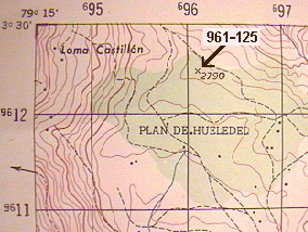
Note that the reference numbers used follow the suggested reference system
given on each map (in Spanish). In the example, the location of the elevation
2790 is derived by first determining the horizontal line to the left, 96 (listed
on the top border) and adding the fractional distance to the next line to the
right, 97. That distance is .1, thus the horizontal part of the reference number
is 961 (96.1) Then take the fractional distance above line 12 (on the left border).
That fractional distance is .5, thus the vertical part of the reference number
is 125 (12.5). Put a dash between the two numbers and the final reference number
is 962-125 Note that the dash is not used in the system given on the maps. Note
also that these reference numbers must include the map name.
Map 4 Location Reference System
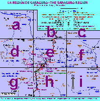 Map 4 is divided into 9 cuadrangles, labeled "a"
to "i" as indicated on the figure to the left. Thus, for example,
the location reference "4e" refers to area covered by cuadrangle "e"
in Map 4.
Map 4 is divided into 9 cuadrangles, labeled "a"
to "i" as indicated on the figure to the left. Thus, for example,
the location reference "4e" refers to area covered by cuadrangle "e"
in Map 4.
SININCAPAC: caves, Inca bath, and waterfall
*Saraguro, 972-986, 2580m, 4e (between "Ñ" and "G")
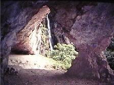
Walk down the Panamerican Highway (towards Cuenca) from Saraguro about 1&1/2 kilometers (~one mile) to the first bridge you encounter (where the car wash is). You will see the caves near the top of a ravine (and just below the edge of the Huelemón plateau) in front of you during part of your walk. After crossing the bridge take the dirt road (to the community of Ñamarin) to the right and then take the first trail up to the right off of the dirt road. Follow this trail on up to the caves. Steps are cut into the bedrock (tuff) on part of the trail. They may or may not be ancient. Other parts of the trail may be slippery and steep. There are some large pot-hole pools below the falls which lies just to the south of the cave system. It is said (evidence?) one of the Incas bathed in one of these pools (Baño del Inca) hundreds of years ago. The cave is wide but shallow with the roof high at front and sloping quickly down to met the floor only a few meters from the entrance. From the caves get as close to the falls as you feel safe doing in order to view the the beautiful, smooth groove cut into a channel by the rushing water and the round pot-hole pool into which the falls runs. A cross is set up in the cave and rituals occur here on Holy Cross day (May 3) as well as at other times.
Note: Although the trip up will be muddier and slipperier, the area is at its
most beautiful on a sunny day after a long heavy rain. Not only will the waterfall
be more impressive, but curtains of water (like a narrow strip of heavy rain)
will be cascading down in front of most of the front of the cave from the cliffs
above while the countryside beyond is bathed in sunlight.
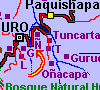
VIRGEN CACA: waterfall
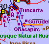
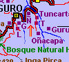
*Saraguro 997972, 2420m, 4h (along river below Oñacapac)
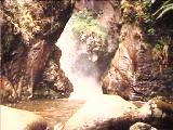
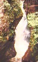
Because of its location deep in the back of a gorge cut into columnar basalt, this is one of the prettiest waterfalls in the region. The base of the Virgen Caca (Virgen of the Rock) can be reached only by a very cold swim. And good views require some scrambling through brush and over rocks.
To easiest way to reach the falls would be to get a ride to Oñacapac (failing that walk there from Saraguro along one of the trails that goes over Huelemón or by way of Ñamarin and Tambopamba). From the northern part of Oñacapac make your way down to the main river, then work your way up the river until you dead end at the falls.
A little below the falls a major tributary enters the river from the east.
Following the ridges to the south of that river should lead to a nice view of
another waterfall in the area, Sharashi (~001-972).
HUELEMON: long, flat ridgetop with views
*Saraguro, 977-987 / 974-955, 2700 / 2850m, 4e, 4h
Huelemon is the relatively flat, plateau ridge, running approximately north-south,
and located about two or three kilometers to the south west of the town of Saraguro.
On a nice day this plateau provides some good views and pleasant walking through
a scattering of pastures and fields and groves of (exotic) pine and eucalyptus
groves. The quickest way there from the town is to follow the directions to
get to the waterfall and cave of Sinincapac
(which are situated just below the north-west edge of the plateau. Just below
the caves a trail to takes off to the right, crosses the creek and takes off
very steeply, to the top of the plateau. If you want a gentler walk, follow
the narrow road leading up to the community of Ñamarin and keep taking
any main trails going off to the right, and you will gradually ascend to north
edge of the plateau.
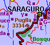
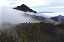
PUGLLA: prominent peak dominating the town of Saraguro
*Selva Alegre, 936-977, 3332m, 4h
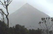
Puglla is easily reached by taking the Panamerican Highway south from Saraguro to the first pass. Finding the trail up the south ridge to the top is a little tricky as it takes off a few hundred meters BEFORE you get to the pass at El Entable (*Selva Alegre 935-967). As you start the steep ridge climb you may encounter a small pond. This is the Laguna de Puglla, about which there are many myths and tales.
The trip up is nice. Unfortunately, however, the top of Puglla is cluttered with communications towers, sheds and construction debris.
We have been told that Puglla and Acacana
were sacred mountains (and one chronicler claimed that Acacana was the "huaca
principal" [principal sacred area] of an ancient group called the "Paltas.")
Modern Saraguros have also said that sometimes they battle, hurling lightening
bolts at each other.
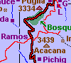
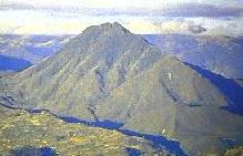
ACACANA: most prominent (but not highest) peak dominating San Lucas area.
*Las Juntas 945-920, 3439m, 4h
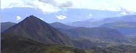
The picture on the left is Puglla and beyond as seen from Acacana; on the right is Acacana as viewed from the highest section of the Huashapamba reserve.
Acacana can be climbed most easily from the north by way of the Lomo de El Oro (the pass along an old loop of the Panamerican Highway). This will require bushwhacking through a short stretch of some very dense cloud forest. More open routes, requiring much more altitude gain, reach Acacana by way of San Lucas and proceed up the southern slopes of the mountain.
Acacana was formerly crowned by a wooden cross. It now has a cement cross
(very ugly and out of place, in our view), but on a clear day you can ignore
that and enjoy the wonderful view.
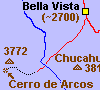
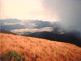
CERRO DE ARCOS: fascinating rock formations in the high páramo
*Selva Alegre, 703-063, 3700m, 4d
Note: on the IGM map Cerro de Arcos is incorrectly located about 3 kilometers
to the north-west (at 684-091) of where I have it located.
Click here for photos of the Cerro de Arcos area. 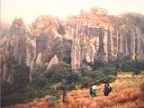
These are rock formations that would be called "hoodoos" in the western US. Though covering only a few hectares on top of a ridge in the middle of wind-swept páramo, these formations are worth seeing if you like wierd rock formations. They include house-sized (sometimes multi-story) rocks in a variety of fantastic shapes and a big clump of intricately eroded rock columns and towers cut by tunnels, arches, and small caves (it might take a guide or plenty of time to find all these features). Small trees (including Polylepis) and bushes of "chuquiragua" (the floral symbol of the high altitude Ecuadorian Andes) grow in the rock-sheltered areas of this otherwise treeless páramo. And if the clouds permit, the views in most directions from the Cerro de Arcos are spectacular.
Dress warmly--high winds and daytime temperatures in the forties are common (and possible, though rare, according to a nearby landowner, are brief periods when the ground may be covered by several inches of snow!).
The hard way to do this trip in a day would be to take a bus to Buena Vista, a small village at 2700 m (just under 9000 feet) between Selva Alegre and Manú, several hours drive to the west of Saraguro. From there it's about a ten mile walk with an elevation gain of over 1000 meters (3000 feet) up to the páramo and across part of it to the end of the drivable area (above an area called Sabadel). From the end of the drivable area to Cerro de Arcos is about an hour's walk with only a moderate elevation gain. The problem here is that the location of the Cerro de Arcos rock formations is not apparent from the road/trail until you are close to them--and even closer on a cloudy day. Thus unless you go with someone who knows the area well, you need to be skilled at route finding with map and compass--again, especially when it's cloudy in the area. So it's probably best to hire a vehicle with a driver who is familiar with the area. It would be about two and a half hours to Buena Vista, and another hour's drive up to the end of the drivable area. If you go early in the morning (say, starting at 4 or 5 am) you'll have plenty of time to do this all in one day--including several hours at the rock formations.
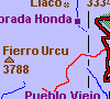
If you really enjoy cold winds and clouds, have a compass (and a GPS for extra insurance), maps and adequate portable shelter, you could spend several days in the high country, eventually dropping down to the Saraguro-Manú road and catching a vehicle back to Saraguro. Or, if you really, really love being in the Ecuadorian páramo you could trek the páramo back several days to the Fierro Urcu area, dropping down from there to Ramos to catch a vehicle on the Panamerican Highway between Loja and Saraguro. Trout fishing is said to be good in some of the streams and lakes in this section of high country.
Or you could head across the páramos towards the south-west and the even higher region of the Cordillera de Chilla, from there dropping down the mountains toward the coast. Or towards the old mining center of Zaruma. ... Get some maps and dream, eh ...
It should be noted that, although frequently cloudy, these stretches of páramo are somewhat drier than the páramos between Saraguro and the upper Amazon basin--cross-country or trail walking therefore is usually less problematic in terms of finding your way through extensive boggy areas.
Note: There is some local interest in making the Cerro de Arcos a tourist
destination--with better road access and maybe even with a refuge. On the day
we were there in 1998 workers with heavy machinery were beginning a project
of road improvement starting up towards the RIo Negro/Sabadel area from Buena
Vista.
FIERRO URCU: high páramo with road access through cloud forest and pastures
*Santiago 3788m, 4g
Fierro Urcu is near the eastern end of a long stretch of high páramo
stretching west and south into El Oro Province. This stretch of páramo
is somewhat drier than the páramos to to the east (Condorshillu to Tambo
Blanco), but also somewhat higher and colder. A nice day trip would be to hire
someone with a high clearance vehicle to take you to the end of the road shown,
spend much of the day wandering the high páramo, then walk down the road
(much of it along the continental divide) through changing vegetation, including
cloud forest (unfortunately, much of it continues to be cleared for pasture).
Then catch a bus back to Saraguro once you reach the Panamerican Highway.


The background design on this page
comes from a Saraguro wool poncho
woven with paired yarns on a back-strap loom.