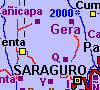
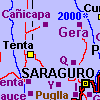
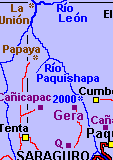
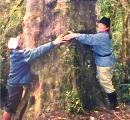
GERA: community beautifully situated on hillslope above deep, dry, often
cloud-filled canyon.
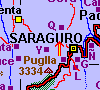
*Saraguro 955055 (2400m)
 A narrow road leads north from the Saraguro area towards Gera. This is a beautiful
walk over hills, below cliffs and along steep mountain slopes.
A narrow road leads north from the Saraguro area towards Gera. This is a beautiful
walk over hills, below cliffs and along steep mountain slopes.
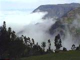
PEÑA BLANCA AREA: cliffs, cloud forest and páramo
*Saraguro 039-966, 3000m, 4h
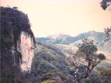
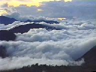 Peña Blanca is a cliff of white rock easily visible from many places
in the Saraguro area. The area includes a trail leading up a ridge through cloud
forest and ending in the páramo. If for some reason you wish to reach
the cliffs, you'll have to bushwhack through some dense cloud forest on a steep
hillside. Take a shelter and sleeping bag and find a place to spend the night
in a high pasture in this area, or on the edge of the páramo, and you
may get a view like this one of the evening clouds filling in the Jubones valley
far below (take your pictures then; the clouds may be completely gone in the
morning).
Peña Blanca is a cliff of white rock easily visible from many places
in the Saraguro area. The area includes a trail leading up a ridge through cloud
forest and ending in the páramo. If for some reason you wish to reach
the cliffs, you'll have to bushwhack through some dense cloud forest on a steep
hillside. Take a shelter and sleeping bag and find a place to spend the night
in a high pasture in this area, or on the edge of the páramo, and you
may get a view like this one of the evening clouds filling in the Jubones valley
far below (take your pictures then; the clouds may be completely gone in the
morning).
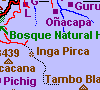
INGAPIRCA: small Inca ruin lying across continental divide in cloud forest
*Las Juntas 974-922, 3170m, 4h
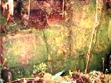 Mostly covered in cloud forest vegetation, and lying right across the continental
divide, are a couple of Inca stone structures. To get there follow the ridge-top
trails along the continental divide to the east and south of the Lomo de El
Oro (the highest pass on an old loop of the Panamerican Highway).
Mostly covered in cloud forest vegetation, and lying right across the continental
divide, are a couple of Inca stone structures. To get there follow the ridge-top
trails along the continental divide to the east and south of the Lomo de El
Oro (the highest pass on an old loop of the Panamerican Highway).
Only a few sections of wall are in view (see photo at right)--some sections of wall have been taken for structures elsewhere, other sections are still covered by vegetation and soil.
There are some good stretches of cloud forest on this trip (including tree ferns, orchids and bromiliads), as well as some open, páramo-like patches, with views, on some ridge-tops.
For more details see on the Ingapirca and the presence of the Incas in
the Saraguro area click here.
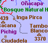
TAMBO BLANCO AREA: cloud forest and páramo along the Continental
Divide
*Las Juntas 020-897, 3370m, 4h
For a good mix of cloud forest and páramo walking, follow the ridge-top,
continental divide several kilometers towards the south-east from
Ingapirca, then a few more kilometers to the north east and across a rather
flat expanse of páramo to the top of Tambo Blanco. The last time I went
through the area to the north-east of Tambo Blanco, a companion and I observed
numerous achupalla plants (ground dwelling bromiliads) whose long, spiny leaves
had been torn off by spectacled bears.
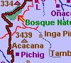
HUASHAPAMBA: protected cloud forest (community land)
*Selva Alegre 922958-935950 (2900m-3260m)
 The
Bosque Natural (Natural Forest) Huashapamba reserve is one of the few areas
along the Panamerican Highway in Ecuador with easy access to fair sized expanse
of cloud forest. You can easily reach it by bus or by walking south on the Panamerican
Highway from Saraguro for a couple of hours until a pass and start down the
other side. The main area starts about a kilometer beyond the pass. If you don't
walk up, at least walk back, taking the first gravel road to the left on the
way back down and cutting through the scenic ridge-top community of Ilincho.
The
Bosque Natural (Natural Forest) Huashapamba reserve is one of the few areas
along the Panamerican Highway in Ecuador with easy access to fair sized expanse
of cloud forest. You can easily reach it by bus or by walking south on the Panamerican
Highway from Saraguro for a couple of hours until a pass and start down the
other side. The main area starts about a kilometer beyond the pass. If you don't
walk up, at least walk back, taking the first gravel road to the left on the
way back down and cutting through the scenic ridge-top community of Ilincho.
There are trails providing access to the interior of the forest, and other developements are planned for tourists. There are also some restrictions on use of this area, and there may be an entry charge.
Click here for more information (in Spanish,
with English summary at the bottom) and pictures on Huashapamba.
SHINDAR: chapel on a hill with a view overlooking Saraguro
*Saraguro 946001 (2690m)
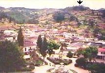
Shindar is a hill rising a kilometer or so to the west north west of Sararguro. Walk up the road (or trails, if you can figure them out) through the community of Quisquinchir to the top of this hill above Saraguro for an good, easily accessible view of the Saraguro valley.
The photo shows Shindar (indicated with arrow) as viewed from above the
park in the center of the town of Saraguro.
CAÑICAPA : community on northwestern edge of Saraguro territory
*Selva Alegre 915055-915045 (2500m-2600m)
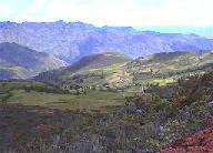
Can be reached by road (no public transportation)--by way of Tenta. Better yet you can walk over the mountains to the west of Quisquinchir. Beautiful views of the Río Llaco and Jubones valley.
If you walk over the mountain notice notice the sloping "ridged fields"
in the upper part of the community. These fields until recently were covered
by brush and forest and are thus quite ancient. As yet investigation has not
revealed their purpose or date. Click here
for more on ridged fields in the Cañicapac area.
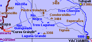
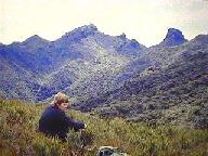
SARAGURO-YACUAMBI TRAIL: trek to the tropical forest
*Saraguro *San José de Yacuambi, 3400m - 1000m, 4e,f
Add *Nabón map if taking Tutupali route
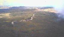
This is a classic trip of one (if you are in VERY good condition) to three days (one way) going up and over the cold páramo and then down, down, down (3000m = 10,000' total vertical descent--very hard on the knees) through cool cloud forests which gradually transition into the tropical rain forests of the upper Amazon basin by the time you get to San José de Yacuambi.
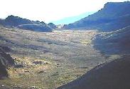
The photo to the left shows the páramo near Condorshillu at a high, windswept elevation of over 3200 meters. To the right is the páramo in the area above the Río Negro.
A variety of routes can be taken. Easiest is to start from the "Curva Grande" (after getting a ride there). The standard route leads south of Condorshillu and by Tignas. The trip by way of Tutupali is interesting, but it can be very difficult to find the correct trails in very foggy conditions in the Páramo. I should confess that both times I've been on the Tutupali route--once going one way, once the other--I've gotten lost!
There is bus service connecting Yacuambi with Zamora and Loja (and return
to Saraguro).
 RÍO JUBONES DESERT AREA: rugged desert, deep canyons
 Few visitors to Saraguro are aware of the desert area only a day's hard walk (one way) from the town. This area, of deep canyons, rushing rivers, cliffs, dry hillsides with a sparse distribution of cactus and acacia trees and ground dwelling bromiliads (and a few poisonous snakes), can be most quickly reached (from the town) by hiring a vehicle for the drive down to the Papaya area. But you can work your way down to the desert by walking through Gera or Cañicapac, or down the east slopes of the Río Paquishapa, starting at Cumbe. Or you could catch a bus to Manú and walk down to the Río Jubones by way of the terraced hilltop of Mochata, or ...
An interesting several day trek could involve connecting Saraguro and Oña
by way of La Union and the canyon of the Río León.
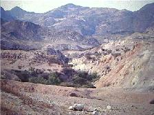
Take plenty of extra water on any trips into this area, and be prepared to do some serious route selection, steep climbing and tricky river crossings.
Click here for more information on the Río
Jubones desert area.
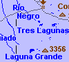
LAGUNA GRANDE / TRES LAGUNAS: many small páramo lakes on high plateau
*Saraguro, 135-999 / 147-038, 3330m / 3300m, 4f / 4f
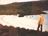
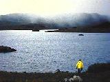 If you insist on sandy beaches and clear water in the Saraguro area, Laguna
Grande may be your only hope! This shallow lake, half a kilometer long, has
a few small beaches and very cold water. Both photos are of Laguna Grande.
If you insist on sandy beaches and clear water in the Saraguro area, Laguna
Grande may be your only hope! This shallow lake, half a kilometer long, has
a few small beaches and very cold water. Both photos are of Laguna Grande.
Four kilometers to the north (and a little east) over a gently rolling, often bog and cushion-plant covered stretch of wind-swept páramo plateau are several more pretty little lakes, Tres Lagunas. And a kilometer or two to the east of Tres Lagunas are several more little lakes perched at the eastern edge of the plateau.
Click here for more on the páramos of
the area.
RIO PAQUISHAPA: following a river gorge from Saraguro area to La Union
*Saraguro *Selva Alegre *Manú 4e
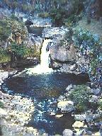
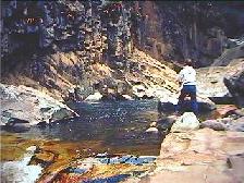 In a beautiful combination of falls, rapids, boulders, cliffs, and still water,
the Río Paquishapa, between the Saraguro area and La Union, flows through
a deep canyon near the bottom of which there is little human occupation. There
used to be excellent fishing in the upper parts of the canyon. Following the
river all the way will require scrambling up and over some high bluffs, and
crossing the river in the absence of bridges.
In a beautiful combination of falls, rapids, boulders, cliffs, and still water,
the Río Paquishapa, between the Saraguro area and La Union, flows through
a deep canyon near the bottom of which there is little human occupation. There
used to be excellent fishing in the upper parts of the canyon. Following the
river all the way will require scrambling up and over some high bluffs, and
crossing the river in the absence of bridges.
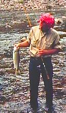 Starting in the 1950s (if not before) local non-indigenous people stocked some
of the local highland rivers (which had no large native fish) with (rainbow)
trout. By the 1960s there was some good fishing for red-fleshed, 2 to 4 pound
rainbow trout in the R�o Paquishapa and some of its tributaries as far downstream
as the junction with the R�o Le�n. Other river systems (e.g., R�o Llaco, R�o
Quinguiado) and perhaps mountain lakes were also planted with trout. By the
seventies and eighties there was some decline in most of the fishery, probably
due to increasing use of fish poisons and dynamite. While fishing in the R�o
Paquishapa is no longer what it was there are still some big rainbows in it
(a 1998 fish story has someone catching a six pounder in the area below the
community of Tuncarta).
Starting in the 1950s (if not before) local non-indigenous people stocked some
of the local highland rivers (which had no large native fish) with (rainbow)
trout. By the 1960s there was some good fishing for red-fleshed, 2 to 4 pound
rainbow trout in the R�o Paquishapa and some of its tributaries as far downstream
as the junction with the R�o Le�n. Other river systems (e.g., R�o Llaco, R�o
Quinguiado) and perhaps mountain lakes were also planted with trout. By the
seventies and eighties there was some decline in most of the fishery, probably
due to increasing use of fish poisons and dynamite. While fishing in the R�o
Paquishapa is no longer what it was there are still some big rainbows in it
(a 1998 fish story has someone catching a six pounder in the area below the
community of Tuncarta).
A stretch of river above O�acapa is currently controlled by the people
of that community (click here for more [in
Spanish] about plans for the fishery in that area) and is closed to all fishing
so that it can serve as a reservoir for continued trout reproduction and growth.
The communities of Las Lagunas, Ilincho and Gunudel have established trout ponds
in their communal forest, Huashapamba, and other communities in the San Lucas
also have trout ponds.
Some lakes and streams in the Fierro Urcu-Cerro de Arcos region have trout in them. Lakes such as Laguna Grande and Tres Lagunas in the p�ramos between Saraguro and the upper Amazon basin are rumored to have had a few trout planted in them by individuals. On a trip through this area in 1994 with several Saraguros we were unable to catch or see any other evidence of the presence of trout in them.
Remote rivers leading down into the Zamora region from the Tambo Blanco p�ramos are said to have been excellent trout streams in the recent past. Don't expect much at this point, but if you are interested in fishing in the area bring some tackle (nothing much is available locally--but can be obtained in Cuenca or Quito) and ask questions (can't give you the information here since rules and conditions can change quickly): 1) what the laws and seasons are; 2) which areas do have fish; 3) which areas might have fish (if interested in doing your own investigation of the possibilities).
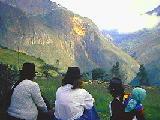
INDIGENOUS FIESTAS
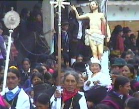
The young girl with angel wings in the photograph will later be suspended from a rope and then lowered and raised a number of times until she can snatch the veil from an image of the virgin Mary below her--announcing to Mary the resurrection of Jesus.
For a very different fiesta celebrated in Saraguro, Carnaval, click here.
The feasting and other events at the homes of the sponsors of the fiestas are semi-private affairs. A wide range of "blood," in-law and ritual (co-godparents, godparents, godchildren) kin as well as close friends of the sponsors are expected to attend in addition to particular persons invited by these people. Those without a designated relation to the sponsor or an invitation from one of these may be considered an intruder or a beggar (or someone looking for handouts of food--which is freely distributed at a fiesta). This does not mean you cannot attent events at a fiesta sponsor's home, but does mean you should not force your presence too closely on the event. It is, in fact, quite likely that you would be invited by someone there to be a "regular" attendee. If you are periferal to an event where food is given out, and you are offered food, accept it all. What you can't eat on the spot you can take with you in a bowl, pot, basket or plastic bag. Don't return any food you can't eat. If you can't take it with you, offer it to someone else. If you happen to become an integral part of the fiesta, your food-handling duties become too complex to detail here--every time you get something, ask someone seated near you what you should do with it (possible things to do: eat it, give it immediately to one or more other persons, take it home).
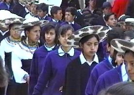
The Diez de Marzo celebrations include musical programs and a long parade of schools and other local organizations. The photograph to the right shows students parading in their school uniforms ("traditional" clothing and hats for indigenous students; blue sweaters, etc. for non-indigenous students).
CARNAVAL: A NATIONAL CELEBRATION YOU MIGHT (OR MIGHT NOT) WANT TO MISS!
Carnaval is the period (up to several weeks long) of letting loose before the restrictions of Lent begin(starting 40 days before Easter) on Ash Wednesday. For a tourist in Ecuador, the salient feature of Carnaval is water fights. Everyone--rich and poor, peasant and priest, young and old, gringo and native, women and men--are subject at any time, and at almost any outdoor (and some indoor) place to attack by water balloons, hoses, buckets of water, dunkings in rivers or fountains, smearings of corn starch, (and worse). There have been instances in Quito where streets were blocked and any vehicle that ventured down them was stopped, and before it was permitted to proceed, its passengers had to be doused with water. Personally never saw this. Urban myth? Maybe. But things can be savage enough without it.
We should note that a Saraguro tradition used to involve throwing flower petals, rather than water, at each other. Well, that can still happen, but watch out for the water that may be lurking behind the petals!
The background design on this page
 Saraguros sponsor a variety of religious and, more recently, secular fiestas (associated with communities or schools).
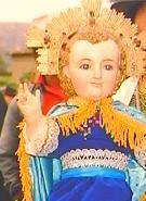 The most elaborate religious fiesta is the Christmas/Three Kings ("Navidad/Tres Reyes") celebration, which lasts for about two weeks (click here to see more).
The photograph on the left shows costumed participants performing at the house of a pair (usually a married couple) of fiesta sponsors. To the right is an image of the Christ Child around which one sponsoring pair organizes devotions and celebrations.
The most elaborate religious fiesta is the Christmas/Three Kings ("Navidad/Tres Reyes") celebration, which lasts for about two weeks (click here to see more).
The photograph on the left shows costumed participants performing at the house of a pair (usually a married couple) of fiesta sponsors. To the right is an image of the Christ Child around which one sponsoring pair organizes devotions and celebrations.
 The two main fiestas sponsored primarily by the non-indigenous population of the town of Saraguro are Saraguro's own independence day--March 10, and the day of the patron saint of Saraguro, San Pedro (St. Peter), June 28.
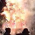
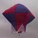 San Pedro includes several days of activities including musical programs, costumed dancers, public dancing, elaborate (and dangerous) fireworks (left photo), and the setting off of hot air balloons (right photo). Late on the visperas (eve) of San Pedro, in addition to hundreds of cohetes and other fireworks being set off, is the firing of the "castillo"--a forty-foot high structure filled with all kinds of fireworks. This is a spectacular event, in part because spectators can be so dangerously close to the activity. At noon on Saint Peter's day, when the 11:00 mass lets out there is a parade of the image of St. Peter around the main plaza and to the edge of the enclosed market. The parade is preceeded and followed not only by more fireworks, but also by the setting off of colorful tissue paper hot air balloons--heated by flaming, wax impregnated rags (click here to see more on San Pedro, including hot air balloons). Yes, they have been known to set off forest fires.
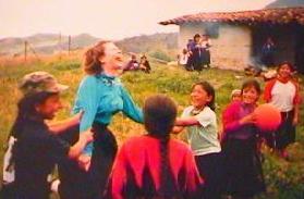
 Actually, Carnaval can be glorious fun for a while if you can also participate as an attacker, especially with a group of friends. But it can be a real hassle for travelers.
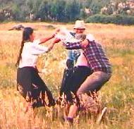
In the photo to the left Linda is about to get soaked; to the right it looks like Jim is even closer to said condition!
Prepared 11/11/2000 Jim Belote & Linda Belote
Updated January 12, 2003
Go to ETHNO-ECO TOURISM, PAGE 1
Go to ETHNO-ECO TOURISM, PAGE 2: PLACES TO VISIT IN THE SARAGURO COUNTRYSIDE
Go to ETHNO-ECO TOURISM, PAGE 4: ARTS AND CRAFTS
Go to SARAGURO HOMEPAGE (www.saraguro.org)

comes from a Saraguro wool poncho
woven with paired yarns on a back-strap loom.